Moki Dugway to Canyons (10/2/23 Mon)
Got up and left Dana's in Durango just after 0700. I rode into rain on my way out of Durango. Stopped for "the second best coffee in the Southwest" at the Silver Bean. Josh would approve, it's an AirStream trailer with serving area, drive-through and inside order/waiting space. More rain while drinking my coffee and eating my buritto which launched a rainbow over the Silver Bean.
My InReach seemed to fully discharge overnight, from 100 to 0 in less then 48h. Admittedly I forgot to start it until after my coffee, then I noticed it needed charging. It seemed to charge fine connected to one of my tiny battery packs. Connected the InReach and external battery pack then stuff both in my jacket pockets. While it charged it was able to start tracking me. If I really want the lost day segment I can pull it from my gps or google location tracking.
When I left Rt 160 for a lesser road, it didn't seem like the best idea at the time. Darker clouds and lightning strikes had been observed from that vector. Good news I didn't die. Eventually I rode out of both the rain and also Colorado.
Another state and another climate change. Utah changed to cool dry and sunny. Most of the day was between 55-65F. Also in the first few miles of Utah, I came upon three horses in the road. At our meeting point the road was going up and had steep drops to each side. Two horses occupied the oncoming lane to me. The third held the higher ground slightly further up the hill and on my side of the road in the grassy shoulder. The two not in my lane could be passed easy, but the third wasn't so happy with me riding between the herd. Spoiler alert, I still didn't die.
I stop for more photos in the sunshine. So my progress likely slowed down in Utah.
On route to Moki Dugway, I hit a few snags. My GPS didn't want me to go that route, and about 2 miles of single lane pavement work blocked the road I needed. In the back of my mind I wondered if the gps was acting on but not sharing road closure intel. I eventually had to wait 20 minutes, but only after two passes by Rt261 and hot steeming pavement they wouldn't let me cross. While hanging with the flag guy I gave the GPS permission to take a dirt road in this instance, and we could then agree to go up Moki Dugway. I need to remember to update that setting later, or it could add unintended excitement to some other segment of my trip. At least I had fueled up at Mexican Hat on my first construction pass.
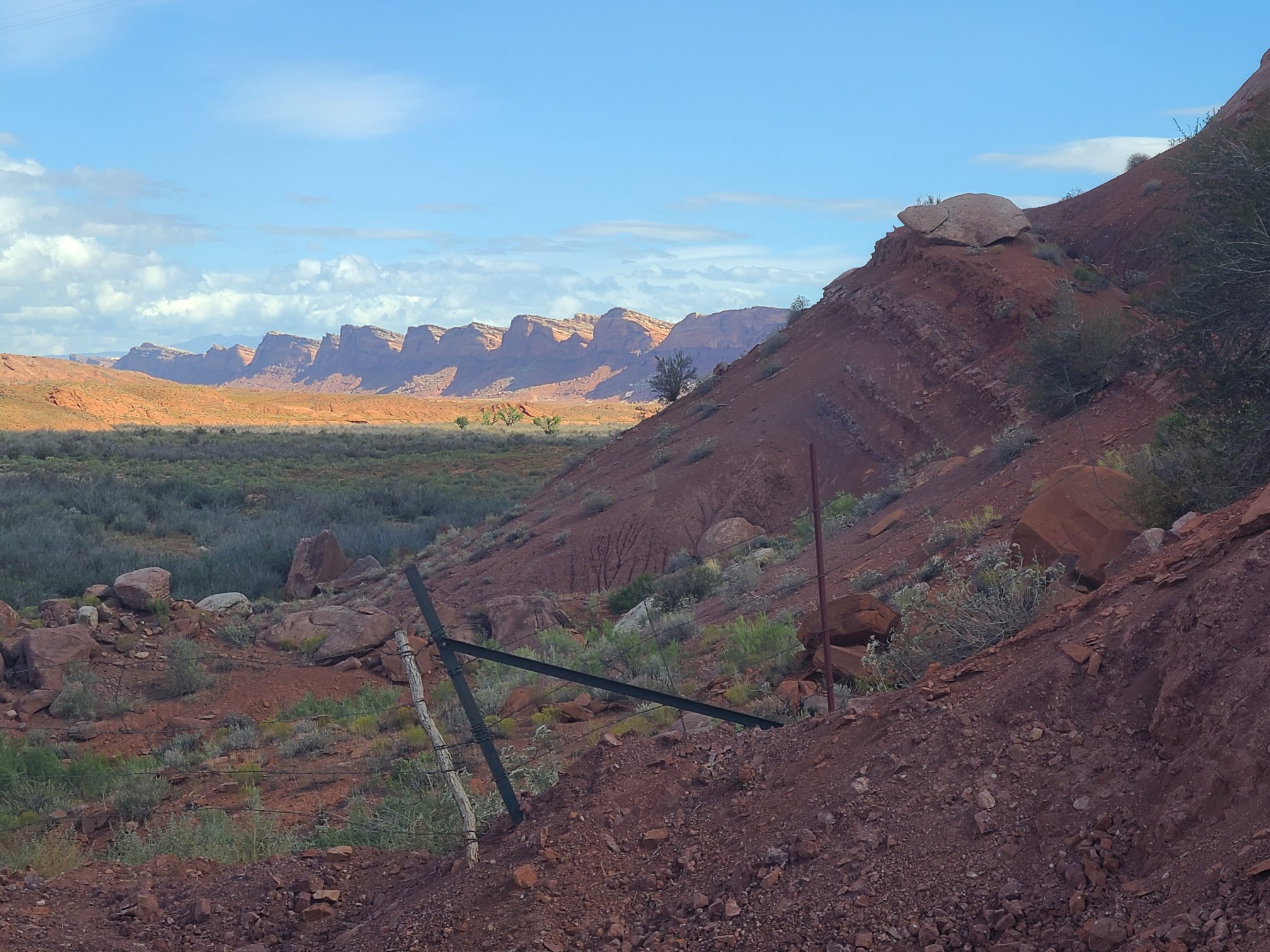
Turns out Moki Dugway is pretty special. It's a cliff climb up switchbacks, and the cliff it climbs is no joke. It's probably a bluff, and is many hundred feet high and miles long. The bluff is a long border of the Valley of the Gods. You drive out this long road accross the valley floor and approach this massive cliff that does not appear to have any weakness that would allow people to scale it. Once at the foot of it you wind around somehow and the road scales the cliff with sheer drops on to one side, then the other. Tight 15mph corners and only little bits of road are paved. The rest is gravel and has significant washboarding. Did I mention the cliff edges above shed large stones. On one straight strech I arrived upon the scene of a full sized road grader and very large loader with a boulder sandwiched between them the size of an Amazon delivery van. They seemed to be taking it down the mountain on the inside edge of the road. As the drop side was to my right, I got to pass them on the outside edge in what seemed like less than my share of the lane. Once past I stopped in the road and snapped a photo of them. Like most photos, it probably will not do it justice. I took many photos going up the swtichbacks. Sometimes just stopping in the road, others on pull offs. There are some great views. Once you arrive on top the cliff it just turns into a normal two lane highway again and goes about it's unassuming way like nothing ever happened.
Except the where it is eventally going is anything but ordinary. With Dana's help threading this path together provided me with an irresistable source of photo ops through long stretches of national park canyons. Not just a little canyon by the major ones: Glenn and Bryce. Those are the biggies, but the road passes through a few other parks as well. I can confirm they look far better than their names imply. National Reef Park, seems like a silly name but the park road winds throuugh miles of canyons, with colorful rocks in a veriety of shapes.
So here's the bad news for you the reader. Eskimos have a huge vocabulary for snow, I have a meager vocabulary for canyons. I saw lots of different canyons but can I explain them differently... Not really. Some are smooth rocks of solid colors, rounded or flat. Some had layers like plywood or some fancy desert. Those layers where at times very uniform in thickness and very parallel, while other times the really thick ones would get undermined by the finer sandy stuff and topple down the hillsides. Most have debris of some type at the base, large blocks, round rollers, find sand. The fine sand type was kind of neat because when left alone it seems to hold up the rest, and in many places produced a wavy edge like a pulled back curtain. In some locations near towns they clearly harvested those fines for some other use. The rock/sand colors included very white, even salted, dark browns and many of shades of red. I guess you could say they had shades of gray too, but get you mind out of the cutter. Most of the time the bright yellow aspen trees failed to grow in the canyons, but in places they added just a touch more color. More often there are just strub sized drab green plants. Sometimes the loose rock and drab plants seem to be holding down the layers below. Many times they slope and muffin top over like a rooftop. Cliffs can just be solid earth edges, but do form free standing pillars, sometimes not so free standing but shoulder to shoulder with friends. In what seems like a free standing wall of attached pillars. A rounded pillar shape doesn't seem that odd in nature, but some of these towers appear very rectangular and house like. Another thing that seemed out of place was how often a slabs of rock break off of a vertical cliff side leaving a vacant arches in the cliff wall, like you've just starting to cut out the first few feet of a cave or tunnel. There are also many round holes in cliff sides and also the large smooth rocks. They look a bit like burrows for cliff birds but I suspect them to be some pocket of air or softer matterial that has since vacated the rock. Luckily for you dear reader there will eventually be pictures.
The end of my day involved riding over a 9500 foot moutain road at 43F on wet roads and dozens of cattle with free access to the pavement. Some cattle walked infront of me as I was heading up the hill and a pickup truck coming downhill with a long traller full of not their hay. Others just ate grass, chewed their cud and watched. Not all waited silently. It''s odd to be standing at a scenic mountain overlook and hear barnyard sounds. For motorcyclists there is also the problem of cattle gaurds accross the roads every few miles, and cow poop. I understand the poop, but don't appreteciate them greasing my road. Technically it's not the cow poop they drop in neat piles, but slurry left by rain and a few hours of traffic. I don't exactly know why they need so many cattle guards, because there seem to be cows on both sides. Maybe different peoples herds? Did I mention that the road seemed like it could be icey?
Once down from the elevation temps returned to the mid 50s. But the sun continued it's relentless march towards darkness. I miss the far north during summer solstice. For many hours of canyon riding I kept saying I need to set the bar higher, and only stop to take photos that score twelve on a ten point scale. Then I would round the next bend to a clear fifteen. On the way to Bryce Canyon, is Hogs Back, it's a spectacular ridge road wtih huge drops and canyons on both sides of a very 3d road. Cool but hard to snap photos of, especially in the last few minutes of daylight.
Luckily when I reached my target BLM campground at Calf Creek with an whole 5 minutes of daylight to spare, I was able to secure a $15 campsite. It came with an exercise plan to walk all my camping gear the 60 feet from parking lot to my campsite. But I had a campsite and I was done for the day. Just had to fish some tasty some grub out of my food bag. Dinner was beef jerky, gorp, and a granola bar. Mmm.
Now for a good nights sleep, hopefully not too cold. I really need to do laundry. I'll be using all my spares tomorrow and have warn all my close multiple days. I need to review how many days I need to reach California and then Texas. It would be nice to find someplace to stay two nights.