Arizona (10/6/23 Fri)
I didn't get to sleep last night until 0200 this morning. But I was up about 0730, and when I looked at the weather for Wellton I decided early riding will still be hot riding. So down I went to enjoy my hotel breakfast. Met a local guy moving from El Centro, CA to here to grow cantalopes. Living just west of here his whole life he could tolerate the heat, but didn't like it. Except his melons like 100F, so he was happy with the current heat. His melon crop is drip watered, I never asked at what scale.
Today's forecast sunshine and 80-105F. On the temperature overlay it's apparent that I rode into the middle of the hottest part of the southwest last night. So I'm riding to the edge of it today. That edge is called Sedona, AZ.
After my 3rd shower in 24 hours I was concerned about the smell when I exited the hotel. I saw no cows, but smelt them. I have previously kicked up road rainwater manuer tea that soaked into my riding gear. So I know it's possible, but I haven't riden in any rain for days.
Route 8 east of Wellton was hazy. Turns out that haze was a very large array of cow stalls, next to large irrigated fields of green. Not sure what the crop was but this was large scale farming. Many fields in a trench irrigation grid. Looked like raised water channels and complex concrete locks to soak any section needed. When not soaking an area these trenches are dry. Fields varried in current use, some flooded, some being harvested by a combine like tractor, others being plowed by a large tractor with even larger plows in tow. I passed by more hazy spots that turned out to be configured much like the first.
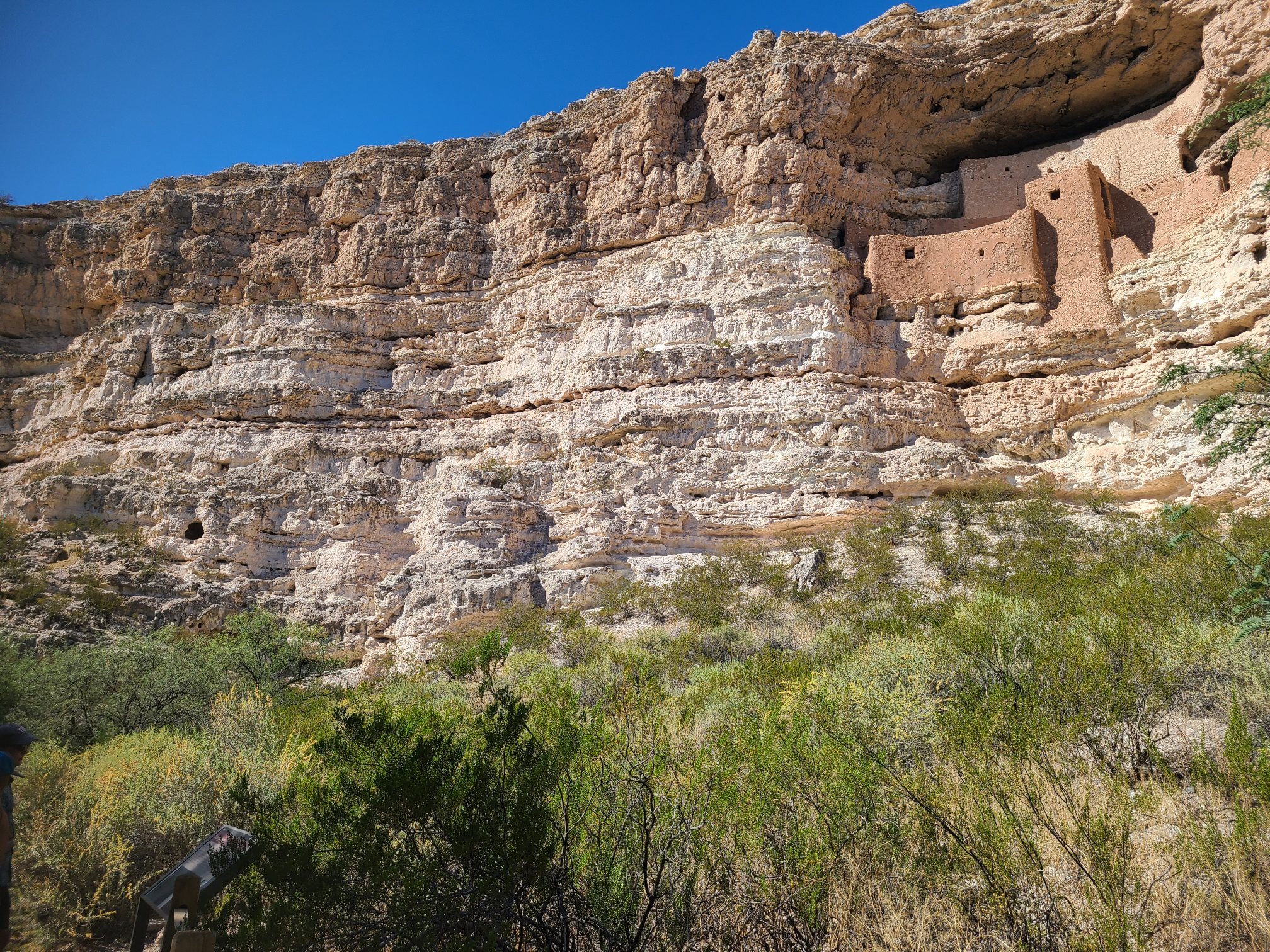
My route to Sedona took me by Montezuma Castle National Monument. It's an built up cave house on a cliff. By built up I mean stone and adobe and at least four floors and 20 rooms. I'ts up in a raised cave that required multipled ladders to reach the lowest living levels. The ladders could be pulled up like multiple draw bridges to secure the dwelling.
One feature that I really liked about this national monument was small placks near trees and bushes naming the plant and it's uses. It was great to see the info and black and white examples of the leaf and nut, as well as the real plant. They did the same thing at their sister monument up the road call Montezuma's Well.
The Well was a large sink whole with a spring fed pond in the bottom. It has a crack that lets out water to an irrigation trench that was used for growing crops.
Neither of these monuments have annything to do with Montezuma. Not really sure why the park system named them this way in the first half of the 1900s.
My temps hit 100F for the second half of have of the day. Hiking around in sandals wasn't too bad. And riding aat 75mph is nice upto about 90F. Then it feels hot. Using a wet bandana around your kneck makes these conditions tollerable. Hopefully i don't need to test 110F or higher.
Leaving the Well I engaged the GPS to Sedona. It told me to u-turn and head back towards the park but continue past the entrance and pavement. Clearly I hadn't turned back on “avoid dirt roads", but I felt adventurous and did as I was told. It was a few miles of gravel to a forest service road. That road headed straight to the highway, but the GPS path kept me on the secondary road. This road actually passes through another town and seems to become a major road through Sedona.
Today I learned that Sedona doesn't allow tents within city limits. So my end of day today was muuch like yesterday, except it started earlier and was only 10 minutes between trys and not the 35 minute rides of last night.
The first place I checked was the town south of Sedona, but the campground listed on the Zumo GPS did not exist. I took photos of very nice houses with red cliff backgrounds. The next campground was in Sedona, whos office closed at 1700, which I reached at 1720. Their sign stated tenting was not allowed in Sedona. So I left Sedona on 89a heading north toward Flagstaff, AZ. There are lots of campgrounds along that river road. At least 4 with "full" signs at their entrance. Then I set course for something further and saw a curious scribble on my GPS. That' scribble became a really tight set of switchbacks that climbed some elevation. A really fun section of road on the bike. Finally I reached the Flagstaff city limits and Fort Tuthill County Park. It's a bit confusing because it's very segmented and the first Park you see has no overnight camping signs. But deeper into the overall park you find a campground, where I now sit and type in my tent. Great sleeping temperatures, I would guess in the low 60F range maybe even a bit lower.
The weather here tomorrow looks decent, but rain comes in by Sunday afternoon. I should be long gone by then, but the front does place rain roughly along the path I hope to take during that timeframe. Something I will have to keep an eye on.